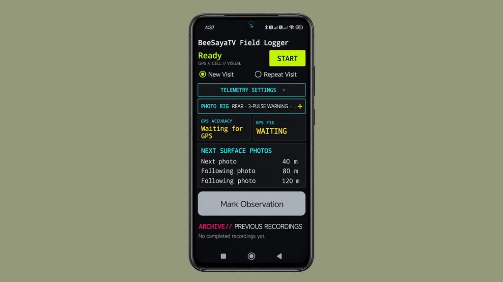
The beesayatv Field Logger is a customized Android application used to record route, connectivity, telemetry, surface, and photographic observations during field visits.
These records support the documentation and reviewed map layers presented in the Trail Atlas. The app works offline and stores each recording on the device until its files are exported for review.
- New Visit — A New Visit records a new GPS route and the enabled field measurements. When photography is enabled, the logger provides vibration cues and captures trail photographs at approximately 40-metre travel intervals.
- Repeat Visit — A Repeat Visit uses a reference package from an earlier recording. The package contains the previous GPS route and stable reference points for earlier photograph locations. Original photographs are not required.
- Repeat photography — While following the previous route, the logger shows the next relevant reference coordinates and their approximate distances. A vibration cue indicates that the hiker is approaching a reference point. The hiker can stop and photograph the trail in the current direction of travel.
- Route deviations — If several reliable GPS observations indicate that the current hike has left the previous route, the logger temporarily switches to approximately 40-metre photography. When the previous route is reliably rejoined, reference-point photography resumes automatically. No manual route-mode selection is required during the hike.
- Mark Observation — Allows manual photographic observations during an active field recording. A dedicated camera flow supports one photo or several views of the same subject, with immediate saving after each successful capture. Notes and categories are added later during editorial review.
- Grouped observation photos — Groups several photographs of the same subject under one observation. Each new observation forms a separate group. Both portrait and landscape photographs are supported, and observation photos remain separate from automatic surface photographs and Repeat Visit evidence.
- Observation location and saving — Each photo retains its capture time and available GPS coordinates, accuracy and fix age in the recording metadata. Photos without usable GPS are kept as incomplete observations. Each successful capture is saved immediately, and fully written photos can be recovered after an interruption. Finishing the observation is not required to retain photos already saved.
- Field-friendly capture controls — Mark Observation and Take photo & save use large, bright yellow buttons with bold labels for easier use outdoors.
- GPS accuracy display — GPS Accuracy shows the phone’s current estimated location accuracy in metres, such as ±8 m. Smaller values indicate a more precise estimate, not a guaranteed error bound. The display shows Waiting for GPS when no fix is available and Fix stale when the reading is no longer current. GPS FIX shows readiness, while Next Surface Photos shows progress toward the next automatic captures.
- GPS uncertainty — Route decisions use location accuracy, distance from the previous GPX track, and consecutive GPS fixes. When accuracy is insufficient, the logger reports GPS uncertainty and avoids changing photography behavior based on an unreliable fix. Closely parallel trails may not always be distinguishable using consumer GPS.
- Photograph locations — Ordinary automatic trail photographs and Repeat Visit evidence retain their location and timestamp records, with GPS coordinates also written into their JPEG metadata. Mark Observation photos keep location and capture metadata separately in the session records. Public copies created during WordPress import have technical image metadata removed.
- Stable reference IDs — Photographs repeated at imported reference points retain their existing IDs. Photographs captured on newly documented route sections receive new IDs. Unvisited reference points are not automatically reported as missed.
- Normal field recording — GPS, connectivity, telemetry, surface observations, and other enabled measurements continue throughout both recording modes, including while the route differs from the previous visit.
- Reference packages — A completed session can produce a metadata-only reference ZIP containing
repeat-package.jsonandprevious-route.gpx. This package can be stored in services such as OneDrive and imported for a later visit. Original photographs and telemetry files are not required for repeat guidance. - Session exports — Normal exports can include the GPX track, connectivity CSV, route-surface CSV, field-telemetry CSV, photographs, photographic metadata, repeat-observation data, and a session manifest. Observation groups are included in
landscape/observations.json, with their photos underlandscape/photos/. The manifest includes observation and photo counts and file checksums. These records are intended for later review and interpretation. - Observation review and Photo Dots — WordPress Field Sessions imports each observation group from the session ZIP as an individual draft with its photo or gallery. Editorial review provides a short note and optional category before publication as one Photo Dot in the Trail Atlas. Reimporting the same observation preserves existing editorial changes. Observations without usable coordinates remain available for review but do not appear on the map.
- Deleting recordings — Recording deletion removes the completed session folder from the phone, including observation photos and ZIPs stored in that folder. Copies already saved elsewhere or imported into WordPress remain independent of the phone recording.
The beesayatv Field Logger App records observations rather than deciding what a route change means. Surface changes, route conditions, environmental differences, and photographic evidence remain subject to later review.